                             - 14 -

    Von vielen Stellen des Kartiergebietes aus ist ein un-
 gewöhnlich weites Panorama des schneebedeckten Hohen
 Himalaya 70 km N' zu sehen. Dieser weite Blick ist möglich
 infolge der tiefen Position der "Midlands" (Anh. II,
 Abb. 6).
                             - 14 -

    From many places of the mapping area one has an unusual
 wide view to the snowpeaks of the Higher Himalaya 70 km N.
 This wide view is enabled by the lower position of the
 Midlands (see fig. II-6).

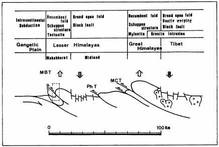
Abb. 5. Vereinfachtes Modell mit den Großstrukturen des
Himalaya in W-Zentral-Nepal (nach SAKAI, 1985/1, S. 391).
Das gestrichelt umrahmte Feld zeigt die ungefähre
Position des Kartiergebietes.
Fig. 5. Simplified model with the largescale structures
of the Himalaya in W-Central Nepal (from SAKAI, 1985/1,
page 391). The dotted framed field shows the approximate
position of the mapping area.
    1.3)         B e s c h r e i b u n g   d e s
                  K a r t i e r g e b i e t e s
     ( M o r p h o l o g i e ,   I n f r a s t r u k t u r ,
                 K l i m a ,   V e g e t a t i o n )

    Das Kartiergebiet liegt in Zentral-Nepal um Tansen und
 Rani Ghat. Die topographische Karte umfaßt 6,6 km W-E und
 10,8 km N-S, d.h. 71 km2, davon wurden ca. 30 km2 kar-
 tiert. Die geographischen Koordinaten des Kartiergebietes
 sind
    1.3)   D e s c r i p t i o n   o f   t h e
                 m a p p i n g   a r e a
    ( m o r p h o l o g y ,   i f r a s t r u c t u r e,
          c l i m a t e ,   v e g e t a t i o n )

    The mapping area is situated in Central Nepal around
 Tansen and Rani Ghat. The topographic map embraces 6.6 km W-
 E and 10.8 km N-S, that means 71 km2, from which about 30
 km2 have been mapped. The geographic coordinates of the
 mapping area are:
83° 30' - 83° 34' E' Länge
27° 51' - 27° 57' N' Breite
83° 30' - 83° 34' E' longitude
27° 51' - 27° 57' N' lattitude
|
|
.
|
    Die Höhen gehen von 400 bis 1570 m üNN.
    Die 3 wichtigsten Ortschaften im Kartiergebiet sind Tan-
 sen, Bartung und Rani Ghat.
    The altitudes reach from 400 to 1570 m above sea level.
 The three most important places in the mapping area are
 Tansen, Bartung and Rani Ghat.
|
