- 63 -
- 63 -
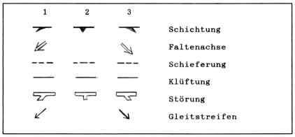
Tab. 4. Die Zeichen in Profilen (vgl. SCHWAN 1974,
Abb. 3). 1: das Element fällt vom Betrachter aus nach
links ein; 2: das Element streicht genau in der Profil-
line; 3: das Element fällt vom Betrachter aus nach rechts
ein. Faltenachse und Gleitstreifen sind verschiedene Line-
are, alle anderen Elemente sind Flächen. Gleitstreifen ste-
hen immer auf dem Zeichen für Störung. Die Beschriftung er-
folgt in der "Geologischen Schreibweise" (Erklärung s.
Anh. II, Kap. 3 und 4).
Table 4. The structural symbols in the profiles (compare
SCHWAN 1974, fig. 3). 1: the element dips left in the
picture; 2: the element strikes in the profile line; 3:
the element dips to the right in the picture. Fold axis and
slip striae are linears, all others are planes. slip striae
are allways togeather with faults. The inscription follows
the "Geological Style" (explanation see appendix II, chapter
3 and 4).
|
|
|
    4.2.1)   S c h i c h t u n g   u n d  F a l t u n g

    Die Schichten im Kartiergebiet liegen für ein Falten-
 gebirge ungewöhnlich flach, dies bezeugen die Gefüge-
 Diagramme für das ganze Gebiet (s. Taf. 14 - 17, Dia-
 gramme der Schichtung). Im Aufschlußbereich erscheinen die
 Schichten meist völlig ungefaltet (s. z.B. Falttaf. 1 -
  7).
    Weder die als Arbeitshypothese angenommene übergeordnete
 Muldenstruktur, durch welche die Tansen-Gruppe erhalten
 geblieben ist (Tansen-Synklinorium), noch eine Spezial-
 Struktur daraus konnte im Kartiergebiet nachgewiesen wer-
 den.
    Die Schichtung des "Tansen-Sandsteins" hat eine Beson-
 derheit. Die Schichtfugen sind lateral nicht weit zu ver-
 folgen. Oft spaltet eine dicke Bank in mehrere dünne auf,
 oder mehrere dünne Bänke werden zu einer dicken. Die Dicke
 dieser "Bänke" reicht von cm bis m. Es scheint, daß das
 gesamte abwechslungslose Sedimentpaket zunächst homogen
 war. Erst im Laufe einer Beanspruchung traten dann Trenn-
 flächen in der Ablagerungs-Ebene auf. Dafür spricht, daß
    4.2.1)    B e d d i n g   a n d   f o l d i n g

    The bedding in the mapping area is unusually flat for a
 fold mountains, this is shown in the orientation-diagrams of
 the whole mapping-area (see plates 14 - 17, diagrams of
 bedding). In the outcrops the bedding mostly seems entire
 unfolded (see e.g. fold plates 1 - 7).
    Nor the hypothetic primary synclinal strukture, by which
 the Tansen Group is preserved (Tansen-synclinorium), nor any
 special structure of it could be established in the mapping
 area.
    The bedding of the "Tansen-sandstone" (tss) has got a
 particularity. The bedding does not lateral continue over far
 distances. Often one thick bank splits up into several thinn
 banks or several thin banks merge to one thick bank. The
 thickness of these banks ranges from centimeter to meter. It
 seems, that the whole monotonous sediment_pack was homogen in
 the beginning. The parting planes in the bedding plane
 appeared later in the course of the tectonic stress. This
 idea is supported by the fact, that in
|
