|
Home -
Gallery
Geology
Music
Software
Hiking
Links
Sport
What?
Thesis Paleontology Balkan Mineralogy Harz Steno 1 10 20 30 40 50 60 70 80 90 Anh A B C D E F 2 3 4 5 6 7 8 9 10 11 12 13 14 15 16 17 18 19 20 21 22 23 24 25 26 27 28 29 30 |
Page 233 of 401
< > |
Stereo-Fotos Anhang V - 9
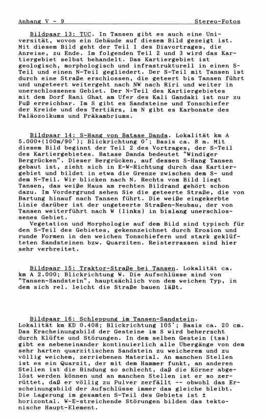
Bildpaar 13: TUC. In Tansen gibt es auch eine Uni-
versität, wovon ein Gebäude auf diesem Bild gezeigt ist.
Mit diesem Bild geht der Teil 1 des Diavortrages, die
Anreise, zu Ende. Im folgenden Teil 2 und 3 wird das Kar-
tiergebiet selbst behandelt. Das Kartiergebiet ist
geologisch, morphologisch und infrastrukturell in einen S-
Teil und einen N-Teil gegliedert. Der S-Teil mit Tansen ist
durch eine Straße erschlossen, die geteert bis Tansen führt
und ungeteert weitergeht nach NW nach Riri und weiter in
unerschlossenes Gebiet. Der N-Teil des Kartiergebietes
mit dem Dorf Rani Ghat am Ufer des Kali Gandaki ist nur zu
Fuß erreichbar. Im S gibt es Sandsteine und Tonschiefer
der Kreide und des Tertiärs, im N gibt es Karbonate des
Paläozoikums und Präkambriums.
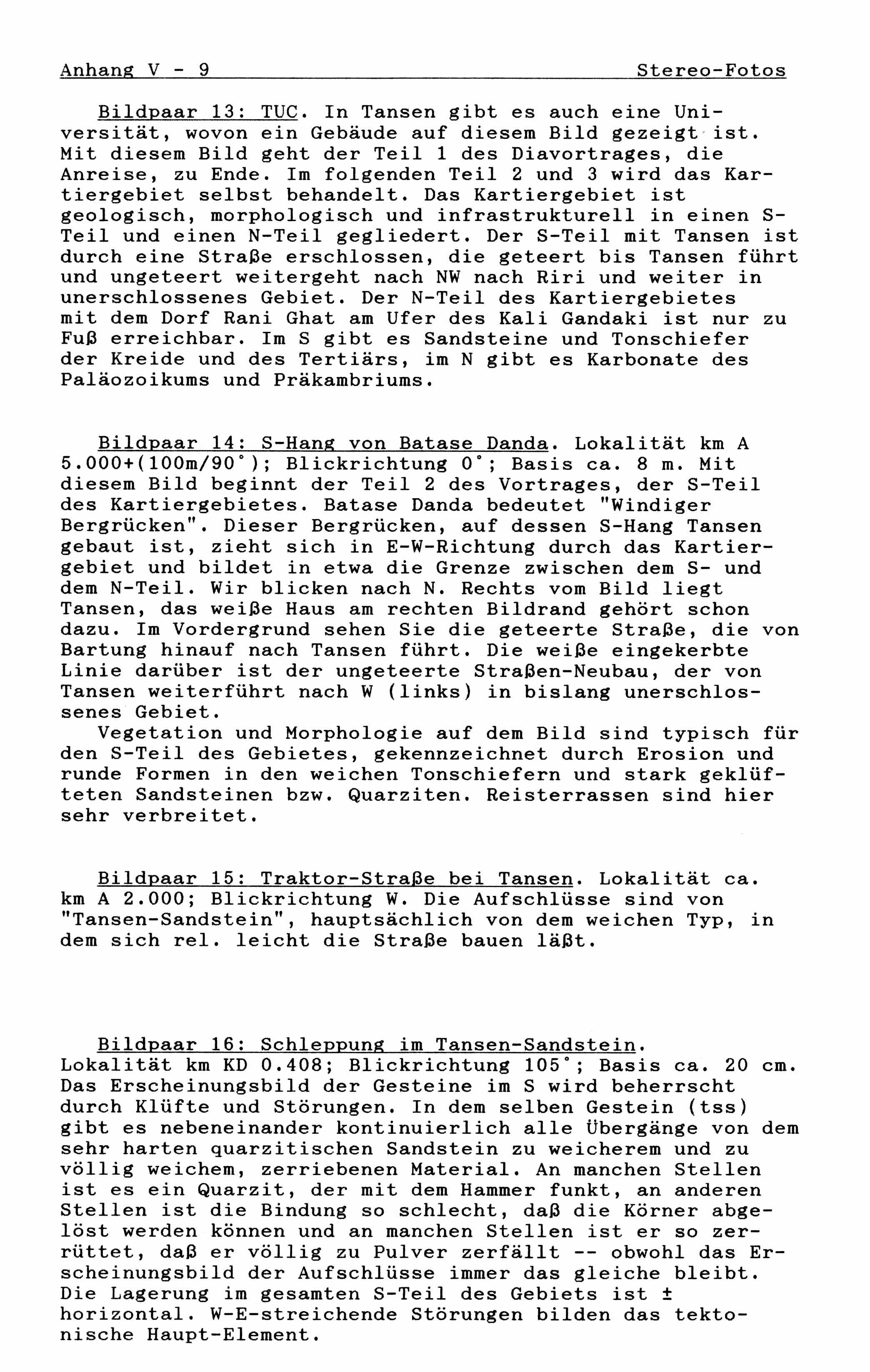
Bildpaar 14: S-Hang von Batase Danda. Lokalität km A
5.000+(100m/90°); Blickrichtung 0°; Basis ca. 8 m. Mit
diesem Bild beginnt der Teil 2 des Vortrages, der S-Teil
des Kartiergebietes. Batase Danda bedeutet "Windiger
Bergrücken". Dieser Bergrücken, auf dessen S-Hang Tansen
gebaut ist, zieht sich in E-W-Richtung durch das Kartier-
gebiet und bildet in etwa die Grenze zwischen dem S- und
dem N-Teil. Wir blicken nach N. Rechts vom Bild liegt
Tansen, das weiße Haus am rechten Bildrand gehört schon
dazu. Im Vordergrund sehen Sie die geteerte Straße, die von
Bartung hinauf nach Tansen führt. Die weiße eingekerbte
Linie darüber ist der ungeteerte Straßen-Neubau, der von
Tansen weiterführt nach W (links) in bislang unerschlos-
senes Gebiet.
Vegetation und Morphologie auf dem Bild sind typisch für
den S-Teil des Gebietes, gekennzeichnet durch Erosion und
runde Formen in den weichen Tonschiefern und stark geklüf-
teten Sandsteinen bzw. Quarziten. Reisterrassen sind hier
sehr verbreitet.
Bildpaar 15: Traktor-Straße bei Tansen. Lokalität ca.
km A 2.000; Blickrichtung W. Die Aufschlüsse sind von
"Tansen-Sandstein", hauptsächlich von dem weichen Typ, in
dem sich rel. leicht die Straße bauen läßt.
Bildpaar 16: Schleppung im Tansen-Sandstein.
Lokalität km KD 0.408; Blickrichtung 105°; Basis ca. 20 cm.
Das Erscheinungsbild der Gesteine im S wird beherrscht
durch Klüfte und Störungen. In dem selben Gestein (tss)
gibt es nebeneinander kontinuierlich alle Übergänge von dem
sehr harten quarzitischen Sandstein zu weicherem und zu
völlig weichem, zerriebenen Material. An manchen Stellen
ist es ein Quarzit, der mit dem Hammer funkt, an anderen
Stellen ist die Bindung so schlecht, daß die Körner abge-
löst werden können und an manchen Stellen ist er so zer-
rüttet, daß er völlig zu Pulver zerfällt -- obwohl das Er-
scheinungsbild der Aufschlüsse immer das gleiche bleibt.
Die Lagerung im gesamten S-Teil des Gebiets ist ±
horizontal. W-E-streichende Störungen bilden das tekto-
nische Haupt-Element.
 Stereo-Photos                                Appendix V - 9

    Picture-pair 13: Tribhuvan University Campus. In Tansen
 exists a small university, of which one building is shown
 in this picture. With this picture part 1 of the color-
 slide-show, the travelling, comes to the end. In the
 following part 2 and 3 the mapping_area itself will be
 shown. The mapping area is geologically, morphologically
 and infrastructurally divided into a northern part and a
 southern part. The southern part, containing Tansen is
 accessible by the metalled road up to Tansen. This road
 continues, not metalled, furter to the NW to Riri_Bazar
 into not yet opened areas. The northern part of the mapping
 area is only accessible by foot. In the southern part
 occure mainly sandstones and shales of the Cretaceous and
 Tertiary, in the northern part occure mainly carbonates
 of the Precambrian and the Paleozoic.


    Picture-Pair 14: South slope of Batase Danda. Locality:
 km A 5.000+(100m/90degree); view_direction: 0 degree;
 stereo-basis: about 8 m. With this picture begins the
 part 2 of the performance, the southern part of the
 mapping area. Batase Danda means "windy hill ridge".
 This hill ridge, on which south slope Tansen is build,
 goes from E to W through the mapping area and it makes
 about the border between the southern part and the northern
 part of it. Beside the rigth side of the picture Tansen is
 situated, the single white house at the rigth margin
 already belongs to Tansen. In the foregroung you see the
 metalled road, which comes uphill from Bartung. The white
 lines above it, which is cut into the hill, is the
 unmetalled road which goes from Tansen to the W to Riri
 Bazar.
    The vegetation and the morphology on this picture are
 typical for the southern part of the mapping_area. It is
 characterized by erosion and by rounded shapes in the soft
 shales and cleaved sandstones, resp. quarzites. Rice
 terrasses are very common.


    Picture-pair 15: Tractor road near Tansen. Locality:
 about km A 2.000; view direction W. The outcrops show the
 "Tansen Sandstone", mainly the soft type, in which
 relatively easy the road is constructed.


    Picture-pair 16: Drag in the "Tansen Sandstone".
 Locality: km KD 0.408; view direction: 105 degree; stereo-
 basis: about 20 cm. The appearence of the rocks in the
 south part of the mapping area is mainly controlled by
 cleavage and faults. In that one rock type (tss) all
 transitions from the very hard quarzite to the very soft
 and mylonitic sandstone exist side by side. At some places
 it sparks with the hammer, at other places it is softer,
 and at other places it crumbles away -- although the
 optical appearence is always the same. The bedding plane
 in the whole southern part of the mapping area is
 plusminus horizontal. W-E-striking faults are the main
tonic element.
|
.